


The path that runs through the Cares River gorge is the most spectacular and well-known hiking route in the Principality of Asturias. It is undoubtedly the most traveled of all the Picos de Europa and, according to numerous statistics, it is also about the busiest mountain route in Spain. It is not lacking in incentives to be a powerful magnet for nature lovers from all over the world; equates its spectacularity and beauty to the ease of its route and in recent times they have been counted more than 200.000 walkers per year.
How was the Garganta del Cares formed?
Without a minimum Historical facts It is difficult to understand how it is possible for a road of so many kilometers to cross the mountain in such a daring way, and we wonder who undertook this project and for what. Even if the first crossing of the Cares was carried out by meritorious mountaineers such as the English Abel Chapman and Walter J. Buck, together with the Marquis of Villaviciosa, Pedro Pidal, the popularization of the route would not arrive until well into the twentieth century and after certain works that enabled the path for the transit of any person.
The oldest route it had a significantly different layout than the current one. Initially It was exclusively for pastoral use and only after 1916 did things change. This was the year in which a sinuous and precarious path began to be delimited so that the operators of the Electra de Viesgo company could monitor and maintain a water channel, a channel that transported part of the Cares flow for its hydroelectric use in the Central de Camarmeña. The construction of this power plant involved the minimum widening of a path with continuous ups and downs, from the Caín dam to Camarmeña. At that time it took about seven hours to go from Poncebos to Caín. Subsequently, the enabled road was used to bring agricultural products from Caín to the Cabrales markets, and only in the 40-50 years the current path was built to improve the maintenance of the canal. The route was opened with pickaxes and dynamite.
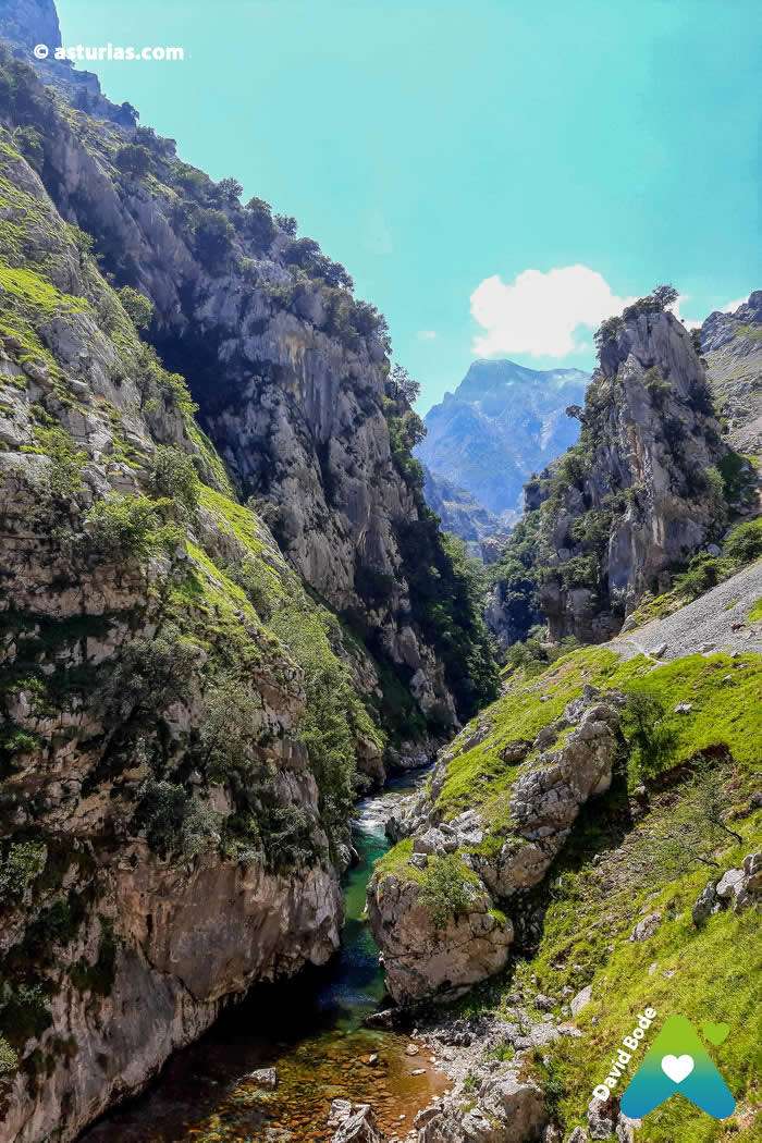
Over time this route became a tourist attraction of the area. It is also known as the Divine Throat, given its spectacular nature, and offers its walkers privileged images along twelve kilometers that mark the division between the Western Massif of the Peaks, or of the Cornión, and the Central Massif or of the Urrieles. If we look up, we will see that the Ruta del Cares is also the beginning of a multitude of channels that cross the strong collapses of the two massifs that it divides. The Mesones canal to the west, or the Dobresengros canal to the central one are two clear examples. In addition, the roof of the Picos, Torre Cerredo, falls vertically on the Cares River, giving more form to its vertiginous canyon.

What is the best time of year to do the Ruta del Cares?
To our understanding it is better to do it in months like May, June or September, thus avoiding the large number of hikers that we will find if we do it in July or August.
Choosing any other date that is not high season is more rewarding if we are looking for the intimacy of the mountain and less heat. With light trainers or boots and a rucksack with the essentials (including a raincoat, just in case), the hike can be undertaken anytime between May and October weather permitting, so just it is about choosing a suitable day to walk.

What to bring to do the Ruta del Cares?
It is advisable to wear water and comfortable shoes mountain boot type; in summer you have to be careful with the sun, we can take hat and sunscreen. It is also advisable to bring warm clothes in case we are surprised by rain or a storm. * Remember that the canal water is not drinkable. Of course do not forget the camera because the views are really spectacular.
How is it better to do the Cares route?
This hiking trail has its development in the Central Massif of the Picos de Europa, between the provinces of Asturias and León. The true Ruta del Cares begins in Poncebos (Asturias) and ends in Posada de Valdeón (León) or vice versa, but due to its long duration, 21 kilometersThis route option can only be undertaken if a car is going to pick us up at our arrival point.
*** To get to Poncebos we will take the AS-114 as it passes through Arenas de Cabrales. There is clear signage.
Where to leave the car to do the Cares route?
Due to the large number of hikers in the entire area, access to Poncebos has been regulated. have been enabled parking areas in Arenas de Cabrales and in this town there bus shuttles to get closer to the start of the Cares route, to take the funicular to Bulnes or travel by minibus to the towns of Tielve or Sotres. You have all the information in the link below.

Cares Route transport plan 2023
This year 2023, in order to avoid traffic jams and offer an alternative to the many...
Currently, the company S-cape Travel ofrece a 3 day package which includes the Ruta del Cares on foot combined with the return in 4×4 in such a way that you do not have to walk there and back. The tourist package includes: accommodation in Arenas de Cabrales (comfortable and cozy family-run hotel with swimming pool), 4×4 excursion in the Picos de Europa National Park, self-guided walking route through the spectacular Garganta del Cares, and route guided ethnographic tour, La Ruta'l Quesu y la Sidra, with food tasting.
Posada de Valdeón - Poncebos Route
· From Posada de Valdeón it will take between 5 or 6 hours to get to Poncebos. Once in the town we follow the road to Cordiñanes; past this village we find the Mirador del Tombo, with a sculpture of the most emblematic species of the Picos, the chamois. The road continues parallel to the Cares River, and shortly after, passing the Chorco de los Lobos, we cross the Corona sheepfold, to reach the people of Cain. After the bridge over the dam, once past Caín, the path narrows, since the walls of the two massifs already form the true gorge. Several tunnels dug into the rock lead us to the Rebecos Bridge and the Bolín Bridge, from where we can see the Cares flowing deep into the gorge. Follow the path and we leave behind the small Culiembro sheepfold, where the channel that bears his name starts, and in a steep ascent it leaves us far above, in the Ostón sheepfolds, in the Cornión massif. The path continues bordering the river, and after a slight climb it brings us closer to the end of the route in Poncebos.
Poncebos Caín Route
From Poncebos to Caín. This is the journey that is normally made. They are 12 kilometers one way and another 12 back. The time is similar to that used in the detailed option from Posada de Valdeón, but in this case we do not have the inconvenience of a third party coming to pick us up at the destination. We can leave the car in Poncebos and pick it up again at the same point after returning from Caín. The route can take us between 3 and 4 hours in a sense and a similar time on the return. The degree of difficulty is low and the unevenness of about 700 meters. After the town of Poncebos, a few meters further on the road turns into a gravel track and a sign indicates the beginning of the Senda del Cares with the legend "Caín 3 h, Posada de Valdeón 6 h". The initial 2,5 kilometers are perhaps the hardest, a continuous slope of a certain unevenness until reaching the ruins of a house and a tree (first shadow in many meters). Shortly after we came to The Collaos, point at which a slight descent begins until finding the path carved in the rock next to the channel. From here the difference is almost non-existent. After five kilometers we reached the sheepfold of Culiembro, from where the channel of the same name rises to the ports of Ostón. We continue walking, we appreciate that it increases the height with respect to the river. We reached the Bolín bridge, where we crossed the river at high altitude, crossing it again shortly after by the bridge of Los Rebecos. Finally, we go through a tunnel area with windows carved into the rock, in the narrowest part of the route and we reach the Cain dam, where the valley begins to open and we will see the houses of the town of Leon.
Sleep in the Picos de Europa
The area has a multitude of hotels, apartments, rural houses, hostels ... a wide variety of establishments to sleep in the area and enjoy this unique environment. In our link we offer offers and direct contact with the owners, without intermediaries or commissions.
Accommodations Picos de Europa
The best rural houses, apartments and hotels in the Picos de Europa. Offers to enjoy in a unique environment. #TourismAsturias…
Books «Asturadictos» and «Picos de Europa. The mountains of light
If you want to know first-hand routes and places like this, we recommend you buy the book «Asturadictos», written by Ana Paz Paredes, journalist and writer, specialist in rural themes of all kinds, gastronomy and tourist routes in the region. Alberto Lastra presents his book «Picos de Europa. The mountains of light, is a lover of mountains and photography. His love for the Picos de Europa has led him to travel through them and photograph them, in search of special places and moments.


Text: © Ramón Molleda for asturias.com
Maximum height: 679m
Minimum height: 229m
Ascent slope: 958m
Descent slope: -720 m
Time spent: 05:03:15
Itinerary: One way, Poncebos - Caín


